
ukmaps.co.uk
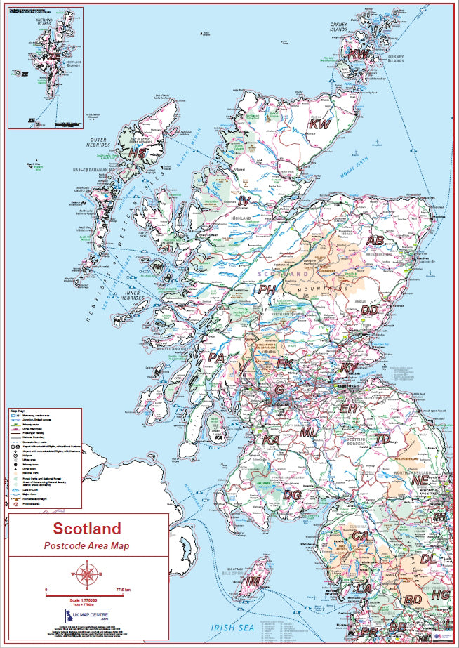
Compact Scotland Postcode Area Map | Scottish Postcode Regions PDF Download
Compact Scotland Postcode Area Map | Scottish Postcode Regions PDF Download
Couldn't load pickup availability
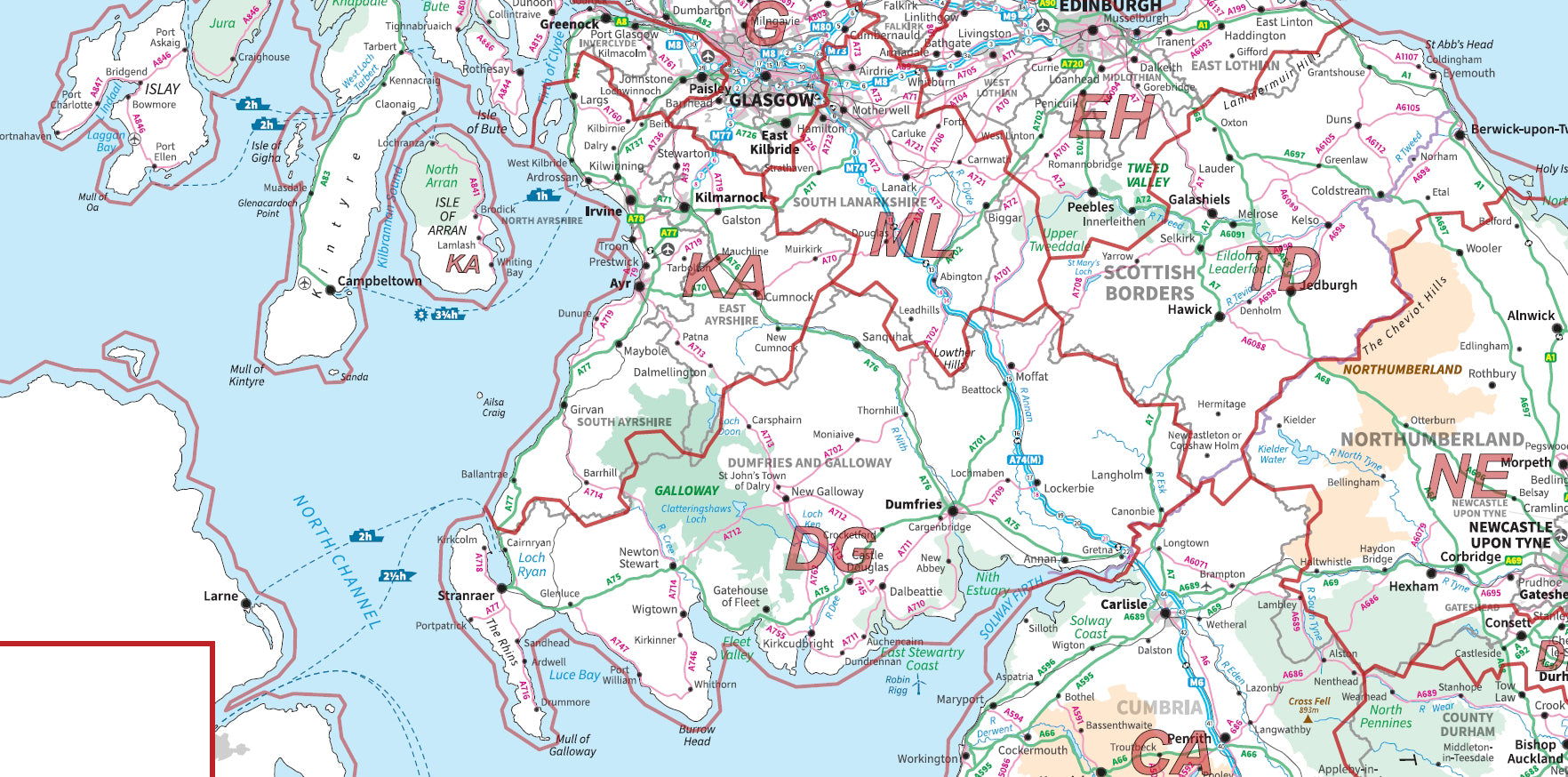
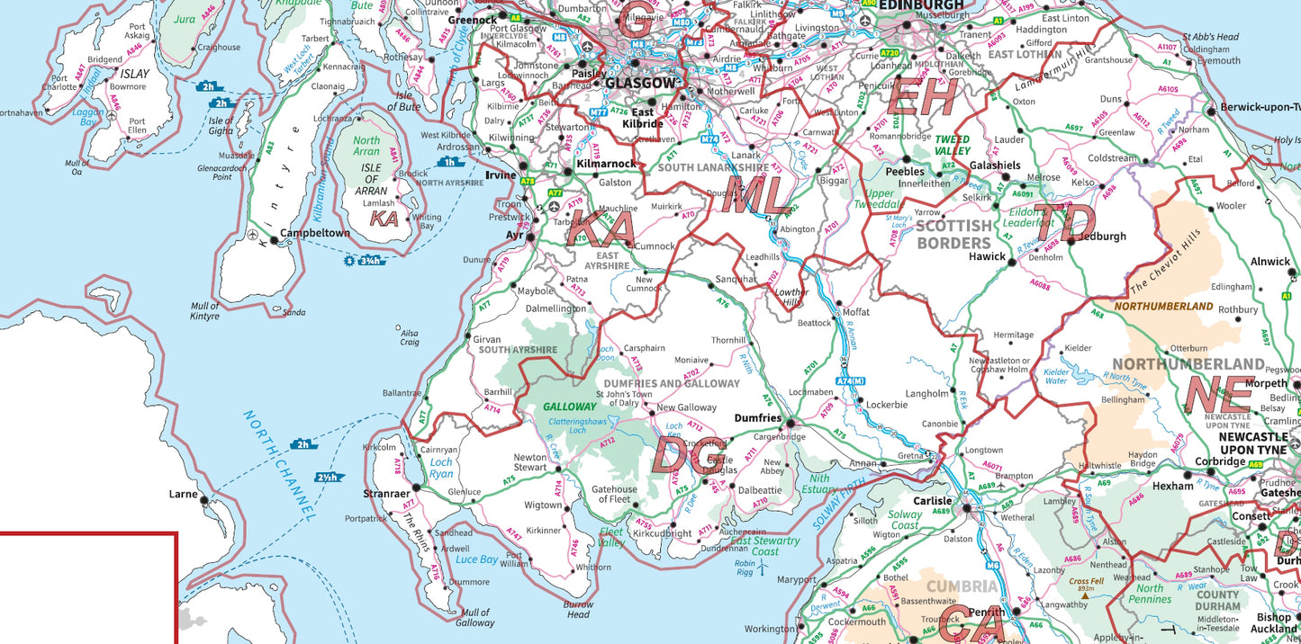
This Compact Scotland Postcode Area Map provides a clear and simplified overview of postcode regions across Scotland, using Ordnance Survey mapping with postcode area boundaries clearly highlighted. Designed for quick reference and business use, it shows key postcode areas such as AB (Aberdeen), EH (Edinburgh), G (Glasgow), and IV (Inverness).
Supplied as a high-resolution, print-ready PDF, this compact map is ideal for office use, presentations, and regional planning where a clean, easy-to-read overview is required.
What is a Compact Postcode Area Map?
A compact postcode area map provides a simplified version of postcode geography, showing the largest postcode regions without excessive detail. These maps focus on clarity and usability, making them ideal for quick visual reference.
Postcode areas represent the top level of the UK postcode system, covering large geographic regions identified by one or two letters (e.g. AB, EH, G).
Key Features & Specifications
- Coverage: Scotland
- Scale: 1:775,000
- Map size: 60cm × 80cm (when printed)
- Format: High-resolution 300dpi PDF
- Base mapping: Ordnance Survey Miniscale
- Postcode areas clearly outlined
- Includes inset for Shetland Isles
What Does This Map Show?
This map provides a clear overview of:
- postcode areas across Scotland
- major cities and regions (Glasgow, Edinburgh, Aberdeen, Inverness)
- key geographic features and layout
- simplified postcode distribution
It allows users to quickly understand postcode coverage without the complexity of more detailed maps.
Postcodes Included
This map includes all major Scottish postcode areas such as:
AB, DD, DG, EH, FK, G, HS, IV, KA, KW, KY, ML, PA, PH, TD, ZE and others.
Common Uses
This compact Scotland postcode map is widely used for:
- quick reference in offices and workplaces
- sales territory planning at a high level
- logistics and delivery overview planning
- presentations and reports
- general geographic understanding of postcode regions
Because of its simplified design, it is ideal for fast decision-making and visual clarity.
Why Choose a Compact Postcode Map?
Compared to larger or more detailed maps, this compact version offers:
- easier readability at a glance
- simplified layout for presentations
- lower file size and faster printing
- cost-effective solution for general use
Compact vs Full-Size Postcode Maps
- Compact postcode map → simplified overview
- Standard postcode area map → detailed regional analysis
- postcode district maps → more granular breakdown
- postcode sector maps → local-level targeting
Digital Download & Print Use
- Instant download after purchase
- High-resolution PDF ready for printing
- Suitable for office walls, reports, and presentations
- Compatible with all standard PDF software
- Print at 60cm × 80cm for optimal clarity
FAQs
What is the difference between compact and standard postcode maps?
Compact maps provide a simplified overview, while standard maps include more detail and larger formats.
Is this map suitable for business use?
Yes, it is ideal for quick reference, planning, and presentations.
What format is the map supplied in?
A high-resolution PDF ready for printing or digital use.
Which postcode areas are included?
All major Scottish postcode areas such as AB, EH, G, IV, and others.
Postcodes Covered on this Map
Postcodes Covered on this Map
AB, BT, CA, DD, DG, DH, DL, EH, FK, G, HS, IM, IV, KA, KW, KY, LA, ML, NE, PA, PH, SR, TD, TS, ZE
Share
About Digital Download Maps
About the Postcode Area Map Series
The Postcode Area Map Series of Maps uses Ordnance Survey Miniscale Mapping overlayed with Postcode Area data. These maps are ideal for businesses and organisations targeting countries or very large regions of the UK,
Digital Downloads
Supplied as a High Quality PDF these maps are set up as 'Ready-To-Print' files which can
be printed at your local large-format print shop to scale. Alternatively this map can be used on any electronic device which has a PDF reader.
Brief Terms
Digital Download Products can not be returned once a purchase has been made. Please read the T&C's before making a purchase.
Please Note:
Once you place an order the file will be available to download for 14
days. If you intend to make multiple prints of the map you should
increase the quantity box accordingly
Custom Maps
If you can't find a map to suit your needs we will happily quote you for a custom map.
Email your request to: custom@ukmapcentre.com or complete our online custom request form via this link > Custom Map Form
FAQ's
Digital Downloads
How will my files be supplied?
Map files are supplied in PDF format and are available to download immediately after payment has completed on the Thank You page through a displayed download link. If you miss this the download link is also emailed to you, so make sure you can access the email address entered at checkout.
Help! I've clicked the download link and I am getting an error or it's telling me the 'link has expired'. Can you help?
Of Course we can help! When you click the download link the file should start downloading via the browser. Usually you can see a download starting at the top right of the browser page, but it is easy to miss. Most PC's and laptops are set up to send downloaded files to the Download folder on the device so it's always worth checking there. If you can't find it get in touch and we'll help get you the file.
Printing the Map Files
Do you supply Printed Maps?
No, we only supply OS mapping in digital format - most often in PDF format. This is easy to open and use on most electronic devices and is also very easy to print from.
Can I have my map files printed?
We don't offer a printing service, but you can take your map file to a local printing company, or send it by email to a national company to have the file printed to your specification.
More Printing Queries
Can I change the print size when I get the map file printed?
We do not recommend changing the print size. All the map files have been created to be printed at Actual Size. This keeps it easy when it comes to printing, just print it at the size it's supposed to be. If the file is scaled then it could become blurry, blocky or otherwise illegible.
Licencing
Can I print a map from the file I've bought?
Yes, typically you are licenced to print one copy of the map from the file purchase. If you want more prints please increase the number of items you want to purchase in the Quantity box.
Can I use the map or parts of it online?
No, you can not publish the file online without the correct licence. This can be obtained from OS, please contact us for more information.
Subscribe to our emails
Be the first to know about new collections and exclusive offers.