

ukmaps.co.uk
London Postcode District Map | SW, SE, E, N Postcode Boundaries PDF
London Postcode District Map | SW, SE, E, N Postcode Boundaries PDF
Couldn't load pickup availability
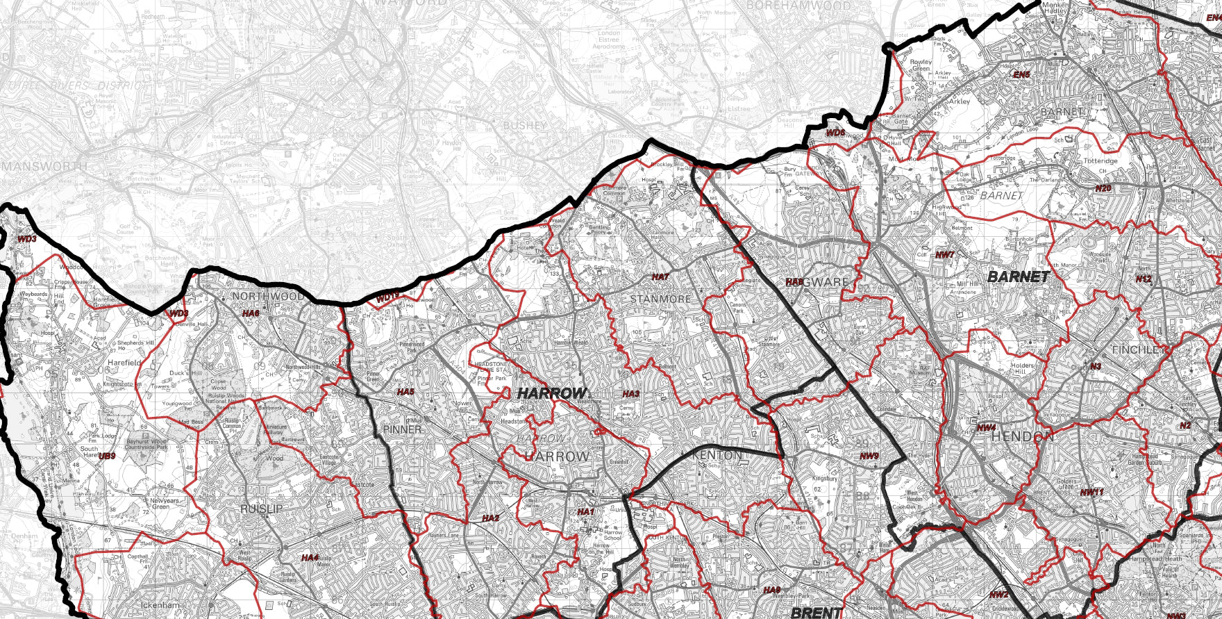
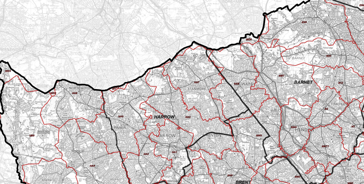
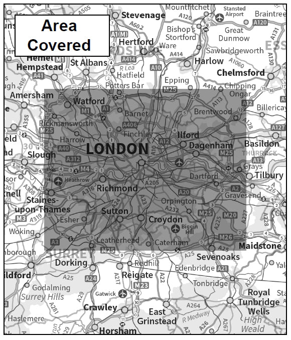
This London Postcode District Map provides detailed coverage of postcode districts across Greater London, including SW, SE, E, N, NW, and Central London regions. It shows districts such as SW1, EC1, W1, and SE1, offering a highly accurate view of postcode geography across the capital.
Based on Ordnance Survey mapping, this high-resolution PDF is ideal for defining delivery zones, sales territories, and urban planning across London.
What is a Postcode District Map?
Postcode districts represent the second level of the UK postcode system, providing more detail than postcode areas.
For example:
- Area: SW
- Districts: SW1, SW2, SW3
In London, this level of detail is essential for accurate targeting and planning.
Key Features & Specifications
- Coverage: Greater London
- Includes postcode districts (SW, SE, E, N, NW, EC, WC)
- Base mapping: Ordnance Survey
- Format: High-resolution PDF download
- Suitable for large-format printing
- Includes Central London detail
What Does This Map Show?
This map provides a clear overview of:
- all London postcode districts
- Central London areas (SW1, EC1, W1)
- borough-level geographic structure
- key transport networks and infrastructure
Common Uses
This map is widely used for:
- defining delivery zones across London
- sales territory planning
- postcode targeting for marketing campaigns
- urban planning and analysis
Particularly useful for businesses operating in high-density urban areas.
Why Choose a London District Map?
London requires more detailed postcode mapping due to:
- high population density
- complex postcode structure
- smaller geographic districts
District maps provide the precision needed for accurate urban planning
Postcode Map Comparison
- Area maps → too broad for London
- District maps → ideal balance
- Sector maps → very detailed targeting
Digital Download
- Instant download
- High-resolution PDF
- Suitable for printing and digital use
Postcodes Covered on this Map
Postcodes Covered on this Map
BR1, BR2, BR3, BR4, BR5, BR6, BR7, BR8, CM13, CM14, CR0, CR2, CR3, CR4, CR5, CR6, CR7, CR8, DA1, DA14, DA15, DA16, DA17, DA18, DA5, DA6, DA7, DA8, E1, E10, E11, E12, E13, E14, E15, E16, E17, E18, E1W, E2, E20, E3, E4, E5, E6, E7, E8, E9, EC1A, EC1M, EC1N, EC1R, EC1V, EC1Y, EC2M, EC2N, EC2R, EC2V, EC2Y, EC3A, EC3M, EC3N, EC3R, EC3V, EC4A, EC4M, EC4N, EC4R, EC4V, EC4Y, EN1, EN2, EN3, EN4, EN5, EN6, EN7, EN8, EN9, HA0, HA1, HA2, HA3, HA4, HA5, HA6, HA7, HA8, HA9, IG1, IG11, IG2, IG3, IG4, IG5, IG6, IG7, IG8, IG9, KT1, KT10, KT18, KT19, KT2, KT22, KT3, KT4, KT5, KT6, KT7, KT8, KT9, N1, N10, N11, N12, N13, N14, N15, N16, N17, N18, N19, N1C, N2, N20, N21, N22, N3, N4, N5, N6, N7, N8, N9, NW1, NW10, NW11, NW2, NW3, NW4, NW5, NW6, NW7, NW8, NW9, RM1, RM10, RM11, RM12, RM13, RM14, RM15, RM2, RM3, RM4, RM5, RM6, RM7, RM8, RM9, SE1, SE10, SE11, SE12, SE13, SE14, SE15, SE16, SE17, SE18, SE19, SE2, SE20, SE21, SE22, SE23, SE24, SE25, SE26, SE27, SE28, SE3, SE4, SE5, SE6, SE7, SE8, SE9, SL3, SM1, SM2, SM3, SM4, SM5, SM6, SM7, SW10, SW11, SW12, SW13, SW14, SW15, SW16, SW17, SW18, SW19, SW1A, SW1E, SW1H, SW1P, SW1V, SW1W, SW1X, SW1Y, SW2, SW20, SW3, SW4, SW5, SW6, SW7, SW8, SW9, TN14, TN16, TW1, TW10, TW11, TW12, TW13, TW14, TW15, TW16, TW19, TW2, TW3, TW4, TW5, TW6, TW7, TW8, TW9, UB1, UB10, UB11, UB2, UB3, UB4, UB5, UB6, UB7, UB8, UB9, W10, W11, W12, W13, W14, W1B, W1C, W1D, W1F, W1G, W1H, W1J, W1K, W1S, W1T, W1U, W1W, W2, W3, W4, W5, W6, W7, W8, W9, WC1A, WC1B, WC1E, WC1H, WC1N, WC1R, WC1V, WC1X, WC2A, WC2B, WC2E, WC2H, WC2N, WC2R, WD19, WD3, WD6
Boroughs on this Map
Boroughs on this Map
Barking and Dagenham, Barnet, Bexley, Brent, Bromley, Camden, City and County of the City of London, City of Westminster, Croydon, Ealing, Enfield, Greenwich, Hackney, Hammersmith and Fulham, Haringey, Harrow, Havering, Hillingdon, Hounslow, Islington, Kensington and Chelsea, Kingston upon Thames, Lambeth, Lewisham, Merton, Newham, Redbridge, Richmond upon Thames, Southwark, Sutton, Tower Hamlets, Waltham Forest & Wandsworth
Share
About Digital Download Maps
About the Postcode City Sector Map Series
The Postcode City Sector Map Series of Maps cover most of the large population centres in the UK using Ordnance Survey Street View Mapping. Scaled at 1:10,000 this mapping provides clear views of all the road names and public buildings. We've overlaid the mapping with Postcode Sector data. This makes these maps ideal for businesses targeting specific areas of a city.
Digital Downloads
Supplied as a High Quality PDF these maps are set up as 'Ready-To-Print' files which can
be printed at your local large-format print shop to scale. Alternatively this map can be used on any electronic device which has a PDF reader.
Brief Terms
Digital Download Products can not be returned once a purchase has been made. Please read the T&C's before making a purchase.
Please Note:
Once you place an order the file will be available to download for 14
days. If you intend to make multiple prints of the map you should
increase the quantity box accordingly
Custom Maps
If you can't find a map to suit your needs we will happily quote you for a custom map.
Email your request to: custom@ukmapcentre.com or complete our online custom request form via this link > Custom Map Form
FAQ's
Digital Downloads
How will my files be supplied?
Map files are supplied in PDF format and are available to download immediately after payment has completed on the Thank You page through a displayed download link. If you miss this the download link is also emailed to you, so make sure you can access the email address entered at checkout.
Help! I've clicked the download link and I am getting an error or it's telling me the 'link has expired'. Can you help?
Of Course we can help! When you click the download link the file should start downloading via the browser. Usually you can see a download starting at the top right of the browser page, but it is easy to miss. Most PC's and laptops are set up to send downloaded files to the Download folder on the device so it's always worth checking there. If you can't find it get in touch and we'll help get you the file.
Printing the Map Files
Do you supply Printed Maps?
No, we only supply OS mapping in digital format - most often in PDF format. This is easy to open and use on most electronic devices and is also very easy to print from.
Can I have my map files printed?
We don't offer a printing service, but you can take your map file to a local printing company, or send it by email to a national company to have the file printed to your specification.
More Printing Queries
Can I change the print size when I get the map file printed?
We do not recommend changing the print size. All the map files have been created to be printed at Actual Size. This keeps it easy when it comes to printing, just print it at the size it's supposed to be. If the file is scaled then it could become blurry, blocky or otherwise illegible.
Licencing
Can I print a map from the file I've bought?
Yes, typically you are licenced to print one copy of the map from the file purchase. If you want more prints please increase the number of items you want to purchase in the Quantity box.
Can I use the map or parts of it online?
No, you can not publish the file online without the correct licence. This can be obtained from OS, please contact us for more information.
Subscribe to our emails
Be the first to know about new collections and exclusive offers.