ukmaps.co.uk
Orkney - OS Map Tiles
Orkney - OS Map Tiles
One-stop resource for up-to-date OS map data for Orkney.
Covering: the Orkney Isles these data sets will be usefull for councils, companies and organisations who need mapping for these areas.
Select between latest edition Ordnance Survey - 50k, 25k, 10k, or Terrain 5 tiles covering the county. Files are supplied as a download link after purchasing. A shape file of the county will be supplied with the tiles.
The 10k Raster, VML and Terrain 5 products use the same tile names and have the same number of tiles.
Standard licence is for 1 year - a reminder to re-licence the data will be sent to you 1 year from date of purchase. If you want to purchase multi-year licenes for this data please get in touch for a custom quote.
Couldn't load pickup availability
Need a Smaller Area? Check out our individual Pages for making custom areas:
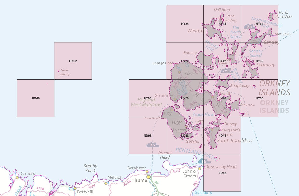
50k Tiles List
50k Tiles List
HX40,HX62,HY00,HY20,HY22,HY24,HY40,HY42,HY44,HY60,HY62,HY64,ND08,ND28,ND46,ND48
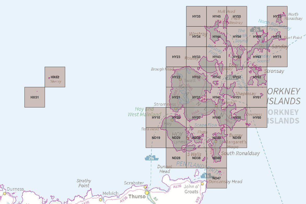
25k Tiles List
25k Tiles List
- HX51,HX62,ND19,HY10,ND28,ND29,HY20,HY21,HY22,HY23,ND38,ND39,HY30,HY31,HY32,HY33,HY34,HY35,ND47,ND48,ND49,HY40,HY41,HY42,HY43,HY44,HY45,ND59,HY50,HY51,HY52,HY53,HY54,HY55,HY60,HY61,HY62,HY63,HY64,HY73,HY74,HY75
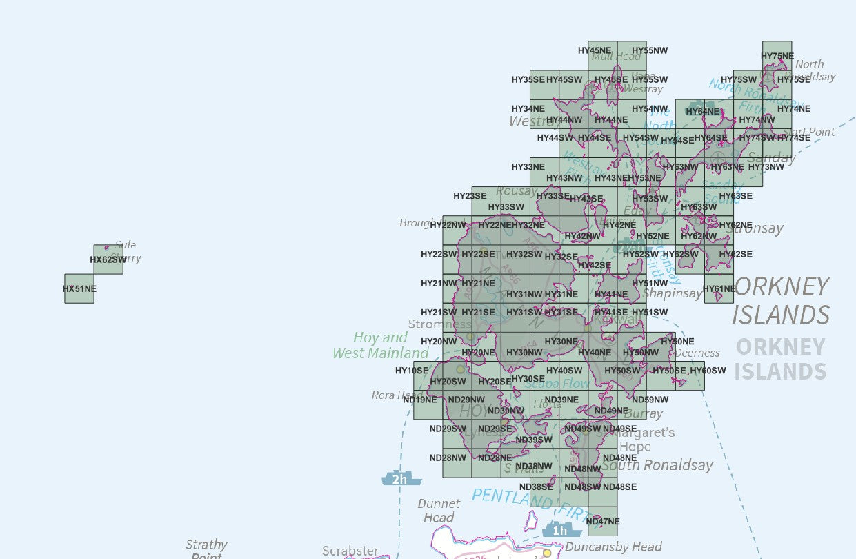
10k Raster/VML/T5 Tile List
10k Raster/VML/T5 Tile List
- HX51NE,HX62SW,ND19NE,HY10SE,ND28NW,ND29SW,ND29NW,HY20SW,HY20NW,HY21SW,HY21NW,HY22SW,HY22NW,ND28NE,ND29SE,ND29NE,HY20SE,HY20NE,HY21SE,HY21NE,HY22SE,HY22NE,HY23SE,ND38NW,ND39SW,ND39NW,HY30SW,HY30NW,HY31SW,HY31NW,HY32SW,HY32NW,HY33SW,ND38SE,ND38NE,ND39SE,ND39NE,HY30SE,HY30NE,HY31SE,HY31NE,HY32SE,HY32NE,HY33SE,HY33NE,HY34NE,HY35SE,ND48SW,ND48NW,ND49SW,ND49NW,HY40SW,HY40NW,HY41SW,HY41NW,HY42SW,HY42NW,HY43SW,HY43NW,HY44SW,HY44NW,HY45SW,ND47NE,ND48SE,ND48NE,ND49SE,ND49NE,HY40SE,HY40NE,HY41SE,HY41NE,HY42SE,HY42NE,HY43SE,HY43NE,HY44SE,HY44NE,HY45SE,HY45NE,ND59NW,HY50SW,HY50NW,HY51SW,HY51NW,HY52SW,HY52NW,HY53SW,HY53NW,HY54SW,HY54NW,HY55SW,HY55NW,HY50SE,HY50NE,HY52NE,HY53SE,HY53NE,HY54SE,HY60SW,HY62SW,HY62NW,HY63SW,HY63NW,HY64SW,HY64NW,HY61NE,HY62SE,HY62NE,HY63SE,HY63NE,HY64SE,HY64NE,HY73NW,HY74SW,HY74NW,HY75SW,HY74SE,HY74NE,HY75SE,HY75NE
Share


About Digital Download Maps
About the County OS Tiles Series
We've created a one-stop place to get OS Map Tiles by County - ideal for councils, public bodies and large companies looking to get quick access to OS data for the Counties across the UK
Terminals and Usage
The Terminals selector is a required field in which you indicate on how many devices or terminals the data will be used. This information is supplied to OS for copyright compliance.
OS Tile data purchased from the UK Map Centre can only be used for Internal Business Use only. This data can not be re-soled or used for commercial gain. Please see our Terms and Conditions here
OS Tiles as Digital Downloads
The tiles are supplied as OS produces them, 25k & 50k Tiles are supplied with World Files, 10k Tiles have the geo-location information embedded within.
The OS tiles are supplied by a digital download link due to the file size.
Brief Terms - OS Tiles
Digital Download Products can not be returned once a purchase has been made. Please read the T&C's before making a purchase.
Please Note:
Once you place an order the file will be available to download for 14
days. If you have a any queries about licencing or terminals please do not hesitate to get in touch.
Subscribe to our emails
Be the first to know about new collections and exclusive offers.


