


ukmaps.co.uk
Scafell Pike 25k A3 - OS Walking Map Download
Scafell Pike 25k A3 - OS Walking Map Download
Couldn't load pickup availability
Scafell Pike 25k OS Walking Map
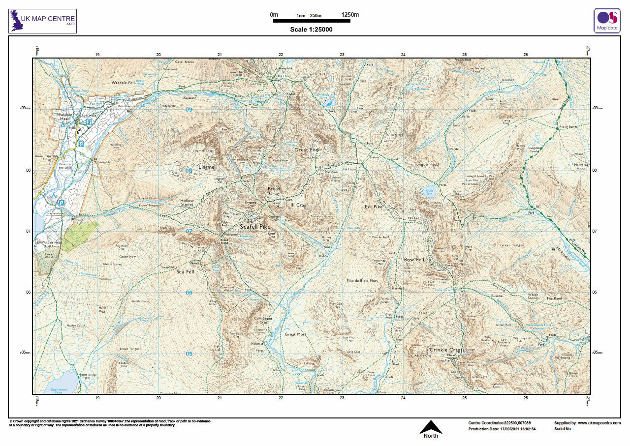
This high-detail digital walking map covers Scafell Pike — at 978 metres, the highest mountain in England — at 1:25,000 scale, equivalent to the detail of an OS Explorer folded map. Designed for printing at A3 size, this map provides the fine path and contour detail needed for precise navigation on and around the highest point in England.
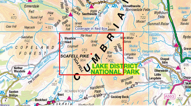
What the Map Covers
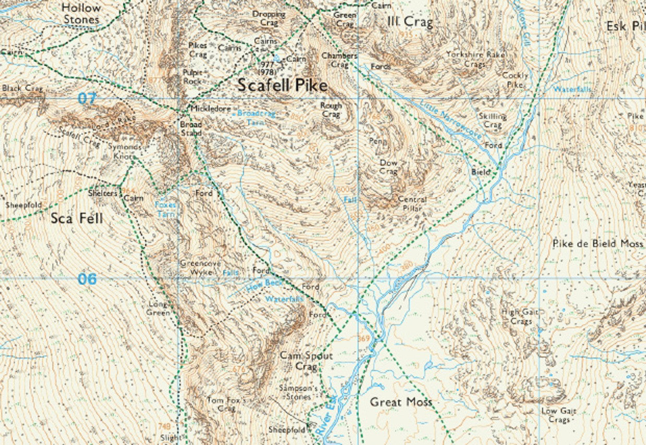
The map covers the full Scafell Pike massif and its main access routes, including the approach from Wasdale Head to the west (via Brown Tongue, Hollow Stones, and Lingmell Col) and from Langdale to the east (via Angle Tarn and Esk Hause). At 1:25,000 scale, individual paths, wall lines, streams, and contour lines are shown with much greater clarity than at 1:50,000. Neighbouring summits including Scafell, Great End, Ill Crag, and Broad Crag are shown in their correct relationship to the main summit.
About the Walk
Scafell Pike is a challenging mountain despite its popularity as the Three Peaks Challenge summit. The terrain is rough and the summit plateau can be featureless in mist, making accurate navigation important. From Wasdale Head the ascent via Brown Tongue is the most direct at around 900 metres of gain; from Langdale via Esk Hause the route is longer but takes in outstanding scenery including Angle Tarn. The 1:25,000 scale of this map makes it especially useful for navigation on the fell, where the additional path and terrain detail helps walkers confirm their position with confidence.
Map Details
Produced from up-to-date Ordnance Survey 1:25,000 scale mapping (Explorer series detail level), updated every three months. The map is supplied as a high-resolution PDF optimised for printing at A3 size — twice the size of A4 — to preserve full readability at this scale. It can also be viewed on a phone, tablet, or laptop. When printing, always set scaling to 100% (Actual Size).
Please note: Once you place an order the file will be available to download for 14 days. If you intend to make multiple prints, increase the quantity accordingly.
Share
FAQ's
Digital Download: Short T&C's
Digital Download Products can not be returned once a purchase has been made. Please read the T&C's before making a purchase. Please Note: Once you place an order the file will be available to download for 14 days. If you intend to make multiple prints of the map you should increase the quantity box accordingly.
Digital Downloads
How will my files be supplied?
Map files are supplied in PDF format and are available to download immediately after payment has completed on the Thank You page through a displayed download link. If you miss this the download link is also emailed to you, so make sure you can access the email address entered at checkout.
Help! I've clicked the download link and I am getting an error or it's telling me the 'link has expired'. Can you help?
Of Course we can help! When you click the download link the file should start downloading via the browser. Usually you can see a download starting at the top right of the browser page, but it is easy to miss. Most PC's and laptops are set up to send downloaded files to the Download folder on the device so it's always worth checking there. If you can't find it get in touch and we'll help get you the file.
Printing the Map Files
Do you supply Printed Maps?
No, we only supply OS mapping in digital format - most often in PDF format. This is easy to open and use on most electronic devices and is also very easy to print from.
Can I have my map files printed?
We don't offer a printing service, but you can take your map file to a local printing company, or send it by email to a national company to have the file printed to your specification.
More Printing Queries
Can I change the print size when I get the map file printed?
We do not recommend changing the print size. All the map files have been created to be printed at Actual Size. This keeps it easy when it comes to printing, just print it at the size it's supposed to be. If the file is scaled then it could become blurry, blocky or otherwise illegible.
Licencing
Can I print a map from the file I've bought?
Yes, typically you are licenced to print one copy of the map from the file purchase. If you want more prints please increase the number of items you want to purchase in the Quantity box.
Can I use the map or parts of it online?
No, you can not publish the file online without the correct licence. This can be obtained from OS, please contact us for more information.
Custom Maps
If you can't find a map to suit your needs we will happily quote you for a custom map.
Email your request to: custom@ukmapcentre.com or complete our online custom request form via this link > Custom Map Form
Subscribe to our emails
Be the first to know about new collections and exclusive offers.